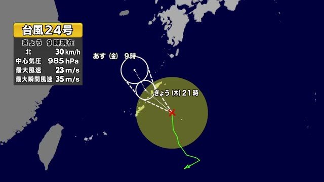
台風24号(名前はクロヴァン)が、沖縄や奄美地方に近づいています。3日から4日にかけて接近し、その後動きが遅くなる見通しです。
Typhoon 24 (international name: Krovanh) is approaching Okinawa and the Amami region. It is expected to come close from the 3rd to the 4th, then slow down.
気象庁によると、台風の中心付近の最大風速は約18メートル、最大瞬間風速は25メートルです。暴風域は伴わない見通しですが、強風や高波には注意が必要です。
According to the Japan Meteorological Agency, the maximum wind speed near the center is about 18 m/s, with gusts up to 25 m/s. No storm-force wind area is expected, but caution is still needed for strong winds and high waves.
台風と前線の影響で、沖縄や奄美だけでなく、西日本や東日本の広い範囲で大雨になる恐れがあります。土砂災害や低い土地の浸水、河川の増水に警戒が必要です。
Due to the typhoon and a weather front, not only Okinawa and Amami but also wide areas of western and eastern Japan may see heavy rain. Caution is needed for landslides, flooding in low-lying areas, and rising rivers.
台風の動きが遅くなるため、影響が長引く可能性があります。船の欠航や交通への影響も出始めています。最新の情報を確認し、避難の準備を進めてください。
Because the typhoon is moving slowly, its effects may last longer. Some ferry services have already been cancelled and transport is beginning to be affected. Please check the latest information and prepare for evacuation if necessary.