JNews

This level is locked

【台風情報】台風26号本州接近で秋雨前線活発化 近畿・東海・関東は29日が雨のピークか 30日も関東で雨続く予報 雨・強風・高波に注意
N3 disaster Original · 1 min read · 108 views · 26 words

台風26号が本州へ接近 秋雨前線の活発化で関東など雨や強風に警戒

Typhoon No. 26 Approaches Japan: Heavy Rain and Strong Wind Warnings Issued for Kanto

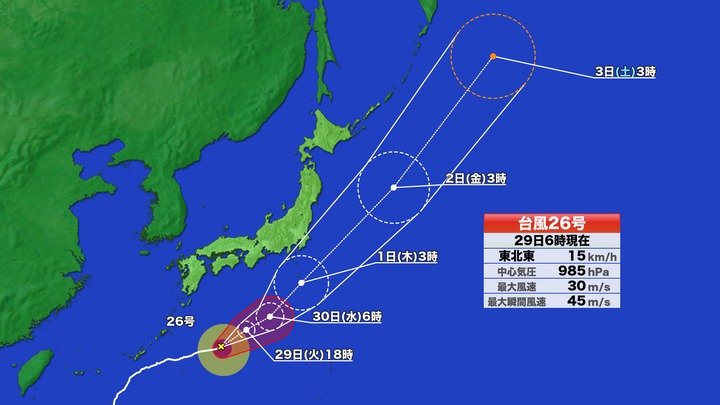
2026年9月29日午前6時現在、台風26号たいふうにじゅうろくごう(スリゲ)は日本の南の海上を時速15キロで東北東に進んでいます。沖縄おきなわの大東島だいとうじま地方では風が弱まりつつありますが、高波への警戒けいかいが必要です。台風は勢力せいりょくを少し落としながら進み、10月1日ごろに伊豆諸島いずしょとうの近くを通過つうかする見込みです。

As of 6:00 a.m. on September 29, 2026, Typhoon No. 26 (Surigae) is moving east-northeast over the waters south of Japan at a speed of 15 km/h. While winds are gradually weakening in the Daito Islands region of Okinawa, caution is still required for high waves. The typhoon is expected to weaken slightly as it moves forward and pass near the Izu Islands around October 1.

台風の接近せっきんに伴い、停滞ていたいしている秋雨前線あきさめぜんせんに暖かく湿った空気が流れ込んでいます。これにより前線の活動が活発かっぱつになり、太平洋たいへいよう沿岸えんがんを中心に激しい雨が降る恐れおそれがあります。進路しんろや速さにはまだ不確実ふかくじつな部分があるため、最新の気象情報を確認かくにんすることが大切です。

With the typhoon's approach, warm and humid air is flowing into the stationary autumn rain front. This is activating the rain front, raising concerns about heavy rain mainly along the Pacific coast. Since there is still uncertainty regarding the path and speed of the typhoon, it is important to regularly check the latest weather forecasts.

近畿きんき地方や東海とうかい地方では29日の午前中に雨のピークピークを迎え、夜にはやむ見込みです。関東かんとう地方も29日午前がピークとなりますが、30日にかけても断続的だんぞくてきに雨が続くと予想よそうされています。特に千葉県ちばけんでは29日夜遅くにかけて強い雨に注意が必要ひつようです。

In the Kinki and Tokai regions, peak rainfall is expected on the morning of the 29th, with rain stopping by evening. The Kanto region will also see peak rain on the morning of the 29th, but intermittent rain is predicted to continue through the 30th. Particularly in Chiba Prefecture, caution is required for heavy rain continuing into late night on the 29th.

気象庁によれば、台風26号は10月1日にかけて強風きょうふうや高波たかなみを引き起こすひきおこす見込みみこみです。伊豆諸島など台風の進路に近い地域では、早めに対策たいさくを行い、土砂災害どしゃさいがいや浸水しんすいへの備えそなえを進めるすすめことが呼びかけよびかけられています。

According to the Japan Meteorological Agency, Typhoon No. 26 is expected to cause strong winds and high waves through October 1. In areas close to the typhoon's path, such as the Izu Islands, residents are urged to take early precautions and prepare for potential landslides and flooding.

Colour by level N5 N4 N3 N2 N1 Tap a highlighted word for its meaning Tap any word you do not know to look it up right here

Frequently asked questions

秋雨前線 (dải mây mưa mùa thu) là gì?

Đây là dải mây mưa hình thành vào khoảng tháng 9 đến tháng 10 hàng năm tại Nhật Bản, khi khối không khí mát từ phía bắc tranh chấp với khối không khí nóng ẩm từ phía nam, gây ra nhiều ngày mưa kéo dài.

Tại sao bão không đổ bộ trực tiếp nhưng vẫn gây mưa rất lớn?

Dù tâm bão không vào đất liền, hơi ẩm nóng do bão mang theo vẫn bị đẩy vào dải mây mưa (秋雨前線) đang đứng yên, khiến dải mây hoạt động mạnh và trút mưa rào diện rộng.

Người dân ở khu vực bị ảnh hưởng bởi bão số 26 cần chuẩn bị gì?

Cần thường xuyên theo dõi bản tin thời tiết, gia cố đồ đạc ngoài trời, kiểm tra vũng thoát nước, chuẩn bị nhu yếu phẩm phòng cắt điện và nắm rõ lộ trình sơ tán đề phòng sạt lở đất hoặc ngập lụt.

Source: Bài luyện đọc do JNews biên soạn

← Articles

JLPT study area

Create a free account to start the JLPT programme and keep all your progress.

or
Forgot password?

Bilingual articles stay free to read, no account needed.

Choose your language

Japanese content always stays — that is what you are here to learn.

Choose your level before you start

Your account has not picked a level yet. Choose one so JNews opens the right roadmap and drills, and saves your progress.

The other four lock once you choose. You can switch later, but the old level’s progress is erased.