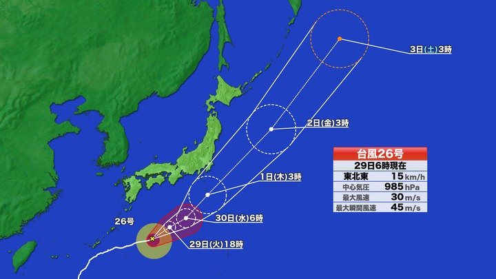
2026年9月29日午前6時現在、台風26号(スリゲ)は日本の南の海上を時速15キロで東北東に進んでいます。沖縄の大東島地方では風が弱まりつつありますが、高波への警戒が必要です。台風は勢力を少し落としながら進み、10月1日ごろに伊豆諸島の近くを通過する見込みです。
As of 6:00 a.m. on September 29, 2026, Typhoon No. 26 (Surigae) is moving east-northeast over the waters south of Japan at a speed of 15 km/h. While winds are gradually weakening in the Daito Islands region of Okinawa, caution is still required for high waves. The typhoon is expected to weaken slightly as it moves forward and pass near the Izu Islands around October 1.
台風の接近に伴い、停滞している秋雨前線に暖かく湿った空気が流れ込んでいます。これにより前線の活動が活発になり、太平洋沿岸を中心に激しい雨が降る恐れがあります。進路や速さにはまだ不確実な部分があるため、最新の気象情報を確認することが大切です。
With the typhoon's approach, warm and humid air is flowing into the stationary autumn rain front. This is activating the rain front, raising concerns about heavy rain mainly along the Pacific coast. Since there is still uncertainty regarding the path and speed of the typhoon, it is important to regularly check the latest weather forecasts.
近畿地方や東海地方では29日の午前中に雨のピークを迎え、夜にはやむ見込みです。関東地方も29日午前がピークとなりますが、30日にかけても断続的に雨が続くと予想されています。特に千葉県では29日夜遅くにかけて強い雨に注意が必要です。
In the Kinki and Tokai regions, peak rainfall is expected on the morning of the 29th, with rain stopping by evening. The Kanto region will also see peak rain on the morning of the 29th, but intermittent rain is predicted to continue through the 30th. Particularly in Chiba Prefecture, caution is required for heavy rain continuing into late night on the 29th.
気象庁によれば、台風26号は10月1日にかけて強風や高波を引き起こす見込みです。伊豆諸島など台風の進路に近い地域では、早めに対策を行い、土砂災害や浸水への備えを進めることが呼びかけられています。
According to the Japan Meteorological Agency, Typhoon No. 26 is expected to cause strong winds and high waves through October 1. In areas close to the typhoon's path, such as the Izu Islands, residents are urged to take early precautions and prepare for potential landslides and flooding.