JNews

This level is locked

Strong Typhoon No. 18 approaches Okinawa and Amami: strict warnings for gale-force winds and high waves
N3 disaster Original · 1 min read · 40 views · 32 words

強い台風18号が沖縄と奄美に接近 暴風や高波に厳重な警戒を

Strong Typhoon No. 18 approaches Okinawa and Amami: strict warnings for gale-force winds and high waves

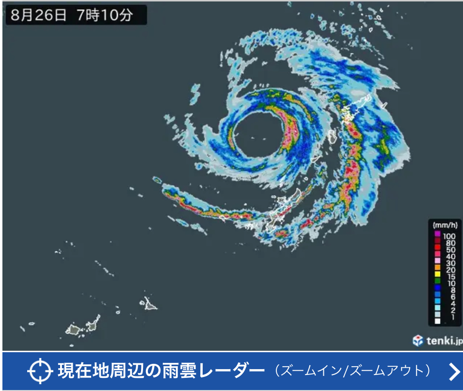
2026年8月26日、強いつよい台風たいふう18号が沖縄おきなわ本島と奄美あまみ地方に接近せっきんしています。気象庁は暴風ぼうふうや高波たか波に厳重げんじゅうな警戒けいかいを呼びかけています。

On 26 August 2026, strong Typhoon No. 18 is approaching the main island of Okinawa and the Amami region. The Japan Meteorological Agency is calling for strict caution against gale-force winds and high waves.

台風の中心ちゅうしん気圧は約960ヘクトパスカルで、最大風速さいだいふうそくは40メートル、最大瞬間風速さいだいしゅんかんふうそくは55メートルを観測しています。多くの地域が暴風域ぼうふういきに入っています。

The central pressure is about 960 hectopascals, with maximum sustained winds of 40 meters per second and maximum gusts of 55 meters per second. Many areas have entered the storm-force wind zone.

26日は奄美地方あまみちほうで最大風速35メートル、沖縄本島おきなわほんとうで30メートルの風が予想されています。波の高さは両地方とも約9メートルで、うねりうねりを伴う高波たか波に注意が必要です。

On the 26th, maximum winds of 35 m/s are expected in the Amami region and 30 m/s on the main island of Okinawa. Wave heights of about 9 meters are forecast for both areas, with caution needed for high waves accompanied by swell.

降水量こうすいりょうは多い所で奄美地方100ミリ前後が予想されています。線状降水帯せんじょうこうすいたいが発生すると、土砂災害どしゃさいがいの危険が高まります。低い土地の浸水しんすいや河川かせんの増水ぞうすいにも注意が必要です。

Rainfall of around 100 mm is expected in parts of the Amami region. If a linear rainband forms, the risk of landslides will rise. Caution is also needed for flooding in low-lying areas and rising river levels.

那覇空港を中心に多くの航空便こうくうびんが欠航けっこうしています。観光客や住民は最新の情報じょうほうを確認し、安全あんぜんを優先して行動することが大切です。不要不急の外出がいしゅつは控えてください。

Many flights centered on Naha Airport have been canceled. Tourists and residents should check the latest information and prioritize safety in their actions. Please refrain from unnecessary outings.

気象庁は引き続き最新さいしんの台風情報を発表しています。住民は避難ひなんの準備を整え、窓まどや戸とをしっかり閉め、停電ていでんに備えることが勧められています。

The Meteorological Agency continues to issue the latest typhoon updates. Residents are advised to prepare for evacuation, securely close windows and doors, and get ready for possible power outages.

Colour by level N5 N4 N3 N2 N1 Tap a highlighted word for its meaning Tap any word you do not know to look it up right here

Frequently asked questions

What does 暴風域 mean?

Is the area around the center of the storm where the average wind speed reaches 25 meters/second or more. When entering this area, the wind is very strong and can knock down trees, damage houses or overturn trucks.

What phenomenon is 線状降水帯?

A linear rain band is a band of rain clouds that extends in a straight line, causing very heavy rain in a short period of time. This phenomenon can easily lead to landslides and sudden flooding, so special caution is needed.

When a storm approaches, what should you do to stay safe?

Follow official information from the meteorological agency, close windows and doors, prepare a flashlight and drinking water, limit going out and be ready to evacuate if instructed.

Source: Reading exercises compiled by JNews

← Articles

JLPT study area

Create a free account to start the JLPT programme and keep all your progress.

or
Forgot password?

Bilingual articles stay free to read, no account needed.

Choose your language

Japanese content always stays — that is what you are here to learn.

Choose your level before you start

Your account has not picked a level yet. Choose one so JNews opens the right roadmap and drills, and saves your progress.

The other four lock once you choose. You can switch later, but the old level’s progress is erased.