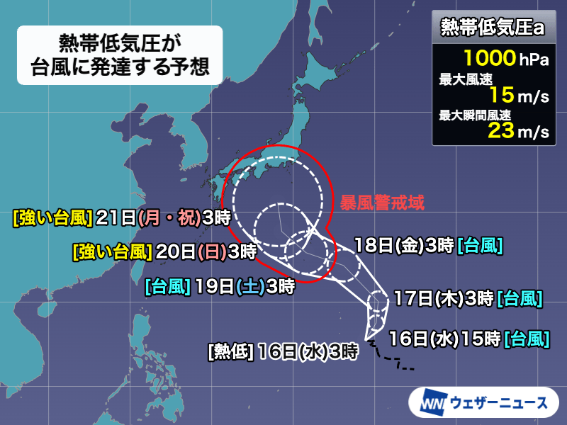
気象庁は、マリアナ諸島付近で発達している熱帯低気圧について、12時間以内に台風へ発達する見込みだと発表しました。発生すれば今月2つ目で、「台風25号」となります。この熱帯低気圧は18日から19日ごろに小笠原諸島へ接近し、その後シルバーウィークにかけて本州方向へ北上するおそれがあります。
The Japan Meteorological Agency announced that a tropical depression developing near the Mariana Islands is expected to become a typhoon within 12 hours. If formed, it will be the second typhoon this month and designated as "Typhoon No. 25". It is likely to approach the Ogasawara Islands around September 18–19 and move north toward Honshu during the Silver Week holidays.
熱帯低気圧は勢力を強めながら西寄りに進み、20日までに強い台風になる予報です。5日先となる21日の予報円の直径は1040キロと大きく、進路の不確実性が高くなっています。太平洋高気圧や気象条件によって移動の向きが変化するため、最新情報に注意が必要です。
The tropical depression is expected to intensify while tracking westward, becoming a strong typhoon by September 20. The forecast circle for September 21, five days out, has a large diameter of 1,040 km, indicating high uncertainty in its path. Since its course may shift depending on the Pacific High and other atmospheric conditions, staying updated with the latest information is essential.
気象庁によると、5日以内に暴風域に入る確率は小笠原諸島で88%と最も高くなっています。また、伊豆諸島南部で14%、三重県や和歌山県で9%、東京都や静岡県、奈良県で8%となっています。広い範囲で強い風への警戒が求められています。
According to the Japan Meteorological Agency, the probability of entering the storm zone within five days is highest in the Ogasawara Islands at 88%. Additionally, it is 14% in the southern Izu Islands, 9% in Mie and Wakayama prefectures, and 8% in Tokyo, Shizuoka, and Nara prefectures. Caution against strong winds is advised over a wide area.
日本付近には秋雨前線が停滞しており、台風から湿った空気が流入する見込みです。これにより前線の活動が活発になり、台風が近づく前から西日本や東日本で雨が強まる危険があります。台風の影響や進路次第では、総雨量が非常に多くなる地域が出る可能性もあります。
An autumn rain front is hovering near Japan, and moist air from the typhoon is expected to flow into it. This will activate the front, bringing a risk of heavy rainfall to western and eastern Japan even before the typhoon arrives. Depending on the typhoon's trajectory, cumulative rainfall could become extremely high in certain regions.
2026年は台風の発生ペースが非常に早く、8月末までの累計数が平年より約10個多く発生しました。特に8月は10個の台風が発生し、1966年以来60年ぶりの記録となりました。秋の台風は移動速度が速く、被害が大きくなりやすいため、事前に対策を整えておくことが重要です。
In 2026, typhoons have been forming at an unusually rapid pace, with about 10 more than the annual average recorded by the end of August. August alone saw 10 typhoon formations, a milestone last reached 60 years ago in 1966. Since autumn typhoons travel quickly and easily cause extensive damage, advance preparation is essential.