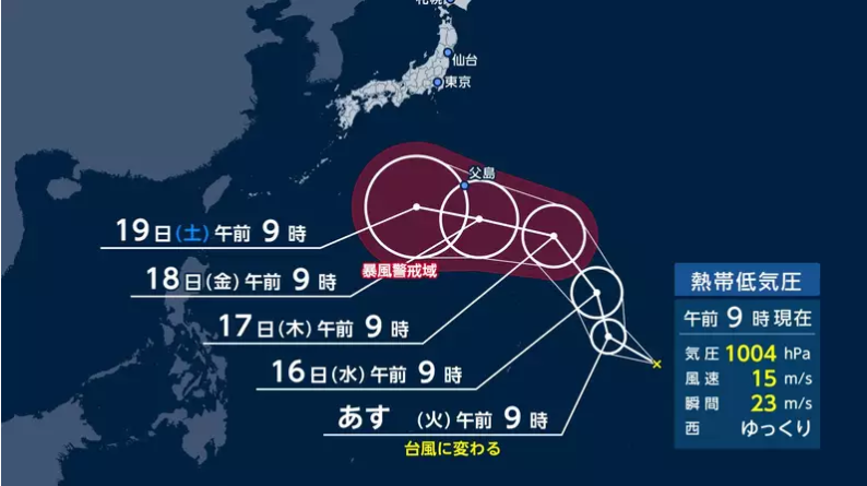
14日午前9時、日本の南の海上にある熱帯低気圧が、今後24時間以内に台風へ変わる予想になりました。今後の動向によっては、連休であるシルバーウィーク期間中の天気に影響する可能性があるため、注意が必要です。
At 9:00 a.m. on the 14th, a tropical depression over the waters south of Japan was expected to develop into a typhoon within the next 24 hours. Depending on its future movement, it could affect the weather during the Silver Week holidays, requiring caution.
この熱帯低気圧は「台風のたまご」と呼ばれ、現在は西へゆっくり進む動きを見せています。今後、発達しながらさらに西へ進み、24時間以内に台風になって小笠原諸島へ影響が出る恐れが出てきました。
Referred to as a "typhoon seed," this tropical depression is currently moving slowly westward. As it moves further west while intensifying, it is expected to become a typhoon within 24 hours, raising concerns of impacts on the Ogasawara Islands.
気象庁のスーパーコンピューターによる計算では、シルバーウィークごろに沖縄の付近でまとまった雨域と、反時計回りの風の流れが描かれています。
According to calculations by the Japan Meteorological Agency's supercomputer, a concentrated rain area and counterclockwise wind pattern are depicted near Okinawa around the time of Silver Week.
暖かい海の上では、こうした雲や風のかたまりが作られやすく、台風がさらに強まる可能性もあります。しかし、まだ数日先の予測であるため、実際にどのように強まるかについては言及できません。今後の経過を確認する必要があります。
Over warm waters, such clusters of clouds and wind form easily, creating the potential for the typhoon to intensify further. However, as this forecast is still several days away, it is not possible to state exactly how it will develop. Continued monitoring of its progress is necessary.
現時点では、熱帯低気圧の進路や強くなる程度を具体的に判断できる段階ではありません。しかし、今後大きく強まる可能性もあるため、シルバーウィークに旅行やレジャーを予定している方は、最新の気象情報をこまめにチェックしてください。なお、この記事はフジテレビ気象センターの気象予報士である岡部茉莉氏が執筆した情報を基にしています。
At present, it is not yet possible to make specific judgments regarding the tropical depression's track or intensity. However, as there is a strong possibility it will intensify, those planning travel or leisure activities during Silver Week are advised to check the latest weather updates frequently. This report is based on information written by meteorologist Mari Okabe of the Fuji TV Weather Center.